
The North Lougheed Area Plan establishes the vision, priorities, land use plan and policies to guide sustainable, forward-looking growth in the North Lougheed Area.
Latest News
On September 29, 2026, Council adopted the North Lougheed Area Plan through Official Community Plan Amendment Bylaw No. 3060, 2026. Please visit the Council Meetings webpage for more information.
The North Lougheed Area is anticipated to develop gradually over many years in response to market conditions and property owner interests. As outlined in the Area Plan, future development will require additional planning, technical studies and Council approvals before specific projects can proceed.
North Lougheed Area
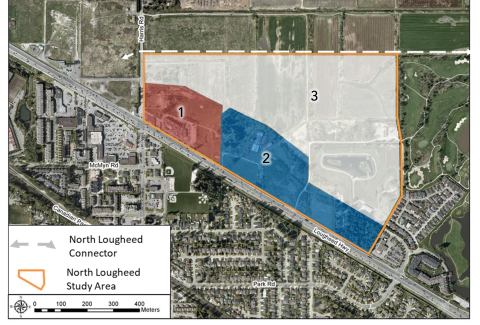
The North Lougheed Area is comprised of approximately 50 ha (125 ac) of land located on the north side of the Lougheed Highway between Meadows Gardens Golf Course and Harris Road.
The North Lougheed Area lies within q̓ic̓əy̓ (Katzie) First Nation’s traditional and unceded territory and is a site of long-term q̓ic̓əy̓ use and occupation. Based on documented information, q̓ic̓əy̓ Peoples occupied and used this area for over four thousand years, consistent with q̓ic̓əy̓ oral histories describing a long-standing relationship with the land and waterways. The area includes places of cultural and archaeological significance associated with this long history of use, including a registered archeological site associated with an Ancestral burial.
The Area Plan addresses a number of local needs by creating housing diversity, generating new jobs and investment, protecting natural and cultural sites, preserving surrounding agricultural properties and enhancing outdoor recreation through new parks and trails. Development will also support the construction of the North Lougheed Connector, which will improve overall traffic flow, enable traffic calming along Old Dewdney Trunk Road and enhance road safety in the agricultural area.

Project Background
The North Lougheed Area has been the subject of various land use planning initiatives and applications to the Agricultural Land Commission (ALC) since the 1980s. In 2019, a multi-phased community planning and engagement process was initiated to prepare an Area Plan for the North Lougheed Area. More recently, the City has focused on additional technical work and collaborative planning with q̓ic̓əy̓. These efforts are intended to support early consideration of cultural context and ensure that q̓ic̓əy̓ perspectives are reflected in the Area Plan, helping to improve understanding, reduce uncertainty and avoid unintended impacts as the area develops.
A report to Council on the North Lougheed Area Plan, including an updated draft Area Plan, was presented at the May 12, 2026 Public Council Meeting. Between May 13 and June 7, residents, property owners, businesses and other interested parties were provided an opportunity to review the draft Area Plan and provide feedback to help inform potential refinements moving forward. A summary of this community engagement and the feedback received is available here: Community Engagement Summary (July 2026)
A report on the North Lougheed Area Plan, including a summary of the most recent community engagement and proposed refinements to the Area Plan, was considered by Council at the July 14, 2026 Engagement & Priorities Committee meeting.
Council granted initial readings to Official Community Plan Amendment Bylaw No. 3060, 2026 – the North Lougheed Area Plan – at the September 1, 2026 Public Council Meeting.
A public hearing for the Bylaw was held on September 22, 2026, and the Bylaw was subsequently adopted on September 29, 2026.
Next Steps
The City will begin working with various interest holders and external agencies to address the implementation items outlined in the Area Plan, including any remaining Agricultural Land Commission exclusion conditions.
Frequently Asked Questions
North Lougheed Connector
The proposed 2-kilometre North Lougheed Connector (NLC) will provide a direct link from Abernathy Way to the Lougheed Highway, order to:
- allow for traffic calming on Old Dewdney Trunk Road to make it safer for area residents and slower moving farm vehicles and machinery;
- provide a more direct traffic route between northeast Maple Ridge and the Pitt River Bridge to reduce traffic congestion and accommodate projected population growth; and,
- provide access to the North Lougheed Area.
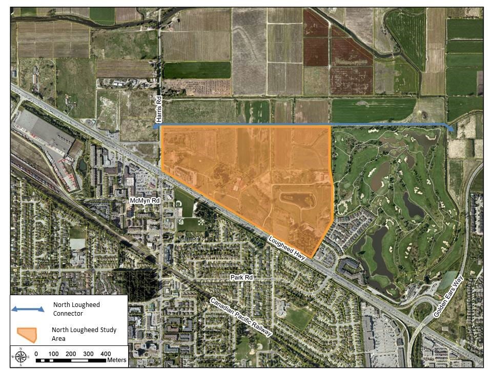
Both in 2007 and today, the NLC has been primarily identified as a way to reduce traffic congestion while simultaneously supporting agricultural producers in Pitt Meadows. The project is expected to be supported through the implementation of the proposed North Lougheed Area Plan.
Staff are working with the Ministry of Transportation and Transit and TransLink to determine how the NLC will connect to Golden Ears Way and Lougheed Highway. This work is anticipated to be tied to other highway and transportation improvement projects to further improve traffic flow in the area and meet increasing demands.
On September 21, 2020, the Ministry of Transportation and Infrastructure announced its intent to engage the Pitt Meadows community with a concept plan for major improvements to the Lougheed Highway/Harris Road intersection. These upgrades will work in tandem with future traffic calming improvements along Old Dewdney Trunk Road and the proposed North Lougheed Connector. Read the City’s media release.
Further questions?
To learn more or ask questions about the North Lougheed Area Plan, contact us at planning@pittmeadows.ca or 604-465-5454.